
Roadtrip! Chasing Waterfalls Across Virginia
Cascade Falls, Virginia
Early autumn is wonderful in Virginia, with lower humidity, comfortable temperatures, and meadows ablaze with bold, hardy Fall blooms. Inspired by a social media post and hungry for a rejuvenating adventure, we hit the open road in search of waterfalls. We spent 6 nights camping and hiking along the Blue Ridge Parkway and in Washington and Jefferson National Forests. This post details our driving, camping, and hiking itinerary — centered around seven major waterfalls — to inspire your next road trip. A map of our driving route is below.
Day 1: Blue Ridge Parkway & Humpback Rocks
As residents of Northern Virginia, Shenandoah National Park is our usual stomping ground for hiking and camping in Virginia. For this week-long road trip, however, we skipped two hours southwards to Waynesboro, where Skyline Drive transitions into the Blue Ridge Parkway (Mile post 0). The Blue Ridge Parkway is an elongated national park and scenic highway extending nearly 500 miles across Virginia and North Carolina. From the Washington D.C. area, we arrived at Humpback Rocks Visitor Center (mile post 5) around lunch time, enjoyed a picnic, a 5 mile leg-stretcher, and a history lesson.
View from Humpback Rocks, Blue Ridge Parkway, Virginia


From the visitor center parking lot, we followed the blue-marked trail a mile up to the top of Humpback Rocks for a panoramic view of Rockfish and Shenandoah valleys; the white blazed Appalachian Trail was our return route back down (total round-trip was about 5 miles). Heading back to our car, we strolled through the Mountain Farm, an expansive outdoor history exhibit with placards detailing how early settlers lived and farmed in the 1800’s. No waterfalls on day 1, but plenty of gorgeous overlooks, outcroppings, and high mountain vistas along the Parkway.
We exited the Parkway near Lexington, Virginia and headed down Interstate 81 to the KOA campground just off Route 11 near Natural Bridge. As far as commercial campgrounds go, the place was well-kept, clean and surprisingly quiet for how compact the sites are. It was fine for just a night and set us up well for an early start the next day in Natural Bridge State Park.
Day 2: Natural Bridge State Park, Lace Falls and Apple Orchard Falls
This 215 foot wonder at Natural Bridge State Park is so special that Thomas Jefferson could not help but covet it, purchasing the “most sublime of nature’s works” from King George III of England in 1774 for the bargain sum of 20 shillings (about $165 in today’s terms - in 2013, the arch and surrounding lands were sold at auction for $9 million). No photo really does justice to the ambiance of this little state park. It’s one of those places where the joy of it lies in the senses: cool damp shadows, the quiet ripples of Cedar Creek, pungent dewey moss, flittering butterflies and chirping birds. Mercifully, there was no crowd early in the morning and we ambled along the paved trail at a leisurely pace.


If only these limestone walls could speak, what legends would they tell? Welllll, the arched wall opposite the creek reveals one egotistical snippet. Just a few feet above the water, the initials “GW” are carved into the rock and it’s believed (with evidence!) that George Washington himself could not resist leaving his mark here when he surveyed the land in 1750. As I said, it’s a special place! The arch was even mentioned in Herman Melville’s Moby Dick, “for an instant, his whole marbleized body formed a high arch, like Virginia’s natural bridge…”.


The 1.5 mile long trail follows Cedar Creek through the arch, passing an educational exhibit of Monacan Native American life and a saltpeter cave that Thomas Jefferson leased to bat poop miners (their potassium nitrate droppings are apparently a key ingredient in gunpowder). There’s also a mysterious underground river that nobody has ever been able to source. The trail terminates at Lace Falls, which flows gently over a 30 foot slide. It’s admittedly not the most impressive waterfall, but lovely and peaceful nonetheless. Read on for more dramatic plunges!

James River, Virginia
From the Natural Bridge, we drove back to the Blue Ridge Parkway, crossed the massive James River and returned to the Appalachian Ridgeline. By lunch, we arrived at Sunset Field Overlook (mile post 74), a sunny and vibrant meadow buzzing with busy bees and playful butterflies. The trailhead to Apple Orchard Falls descends 1.5 miles (2.5 km) down the mountain, starting at an elevation of 3500 feet. The grade is aggressive, but well-maintained. Sunlight filters through the forest, nurturing a prolific green ground cover with golden yellow flowers. About 3/4 of the way down is a small but mighty “upper” fall, a hint of what’s to come. We saw a couple in bathing suits getting a nice soak under the shower; alas, we were unprepared for this and simply continued onward to the main plunge.


Apple Orchard Falls, Virginia
The trail descends down a steep staircase, which is your cue that the falls are just around the corner. There’s a terrific viewing platform that crosses right in front of Apple Orchard Falls, with a bench to sit, relax and enjoy the soothing sound and refreshing spray. After a brief respite, we made our way back up the mountain the way we came.
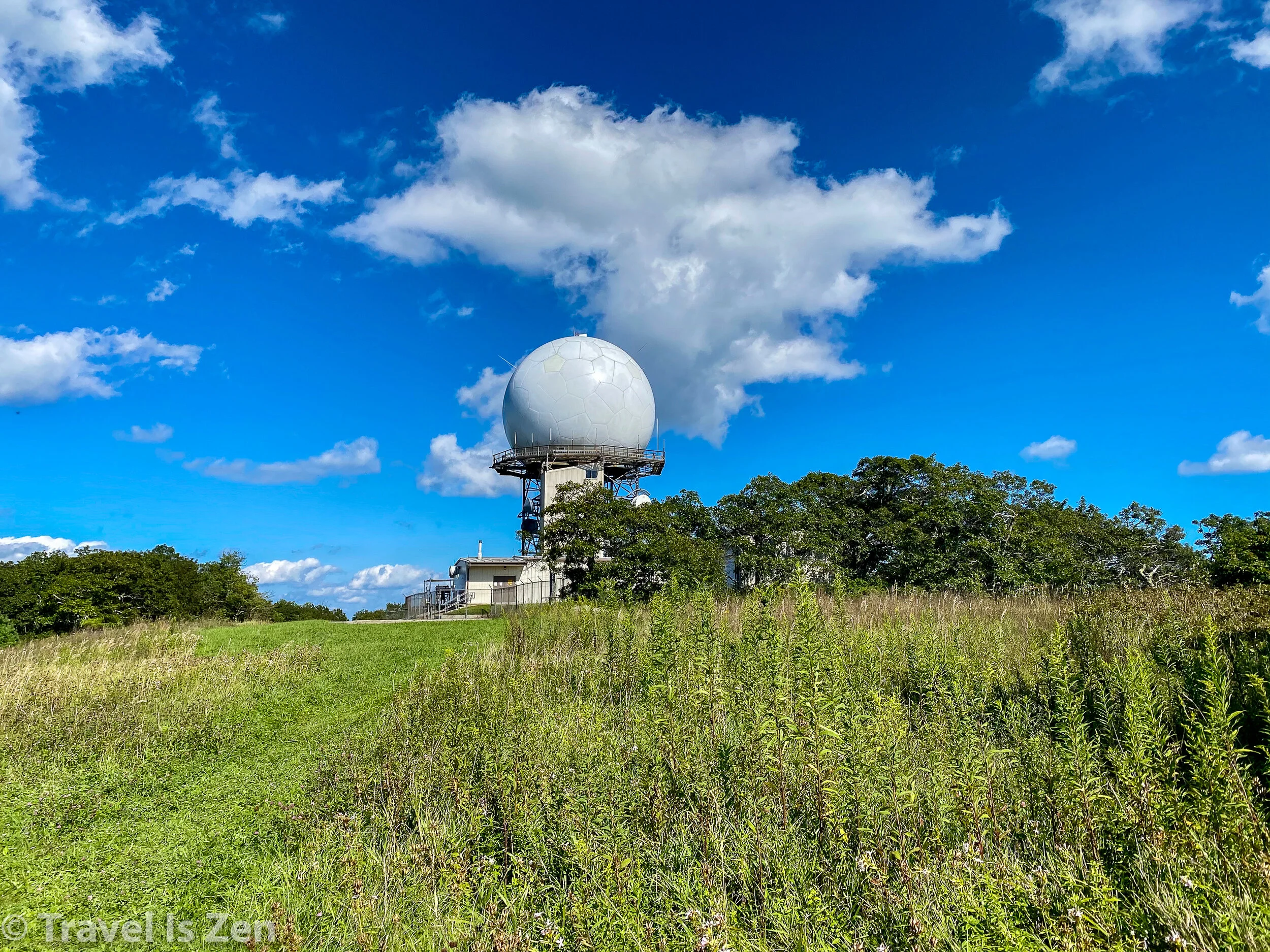
Near the starting point at Sunset Field Overlook, the trail intersects with the Appalachian Trail. We continued along the AT to the top of Apple Orchard Mountain, surprised to see the giant soccer ball we had spied from the Blue Ridge Parkway earlier in the day. Given the 360 degree panoramic views of the Virginia countryside and a few other clues, we deduced that this must be some sort of Air Force satellite. Cool!

We hiked back to our car and continued along the Parkway another 15 miles or so, checking into Peaks of Otter campground near supper time. There is a pretty lodge at Peaks of Otter, situated beside a serene lake and surrounded by three mountains. The lodge has a restaurant and wifi, if you need to check in on “life”. The campground is just up the road; it has bathrooms with running water sinks, but no showers. There are black bear in the area, so make use of the bear boxes if you’re toting in any food. Better safe than sorry.
Day 3: Fallingwater Cascades and Bent Mountain Falls
Fallingwater Cascades, Blue Ridge Parkway, Virginia
Our original plan was to hike to either Sharp Top or Flat Top peak in the morning, which are both accessible from the campground, followed by the falls later in the day. We awoke to a downpour, however, and the peaks were shrouded in thick clouds. Saving those for a future road trip, we headed straight to the waterfall. The trailhead to Fallingwater Cascades is just a few minutes from Peaks of Otter campground. Donning ponchos and umbrellas, we did the 3 mile circuit loop in the pouring rain. The best part about a road trip inspired by waterfalls is that rain just makes the falls that much better! We were undeterred and duly rewarded. Fallingwater Cascades trail follows the stream and has several smaller falls along the way. The trail crosses in front of the tallest plunge and heads back up the other side.
The third major waterfall — the second highest in Virginia — is a bit out of the way, south at Bent Mountain. We finished our drive along Blue Ridge Parkway and exited at Milepost 121. After a quick stop in Roanoke, we drove south-west and wound our way up a steep mountain, twisting and turning past scenic farms and expensive estate homes to Bottom Creek Gorge Preserve. This remote little conservation area is a local gem! The Gorge has a unique ecology that provides an essential protected habitat for four rare aquatic species (orange madtom, bigeye jumprock, riverweed darter, Roanoke darter). The signboards as you enter the park share the conservation story. There are several color-coded circuit trails that can be linked into increasingly longer hikes. We chose a four mile loop path leading to the Falls overlook. At 200 feet, the falls are impressive! The roar echos across the valley. If you have binoculars or a zoom lens, bring ‘em, because the falls are across the gorge and best viewed at magnification.


After our hike at Bent Mountain, we headed to Blacksburg and the Washington & Jefferson National Forest. Due to the torrential rain in the evening, we checked into a hotel in Blacksburg for the night, rather than a campground.
Day 4: Cascade Falls in Washington & Jefferson National Forest
From Blacksburg, we drove an hour west to Cascade Falls trailhead. This was our favorite hike of the entire week. The relatively flat trail follows Little Stoney Creek, winding along a shaded mossy path that criss-crosses the stream. The destination for most hikers is the roaring 66 foot Cascades Fall and its pool at the base of a semi-circular set of cliffs overhung with rhododendron and ferns.


Most hikers turn back at this point; however, if you proceed uphill, you will encounter the spectacular top portion of Cascade Falls hidden within a tangle of compact rhododendron. This is definitely “off the beaten path” and well worth the extra 15 minute climb!
Upper Cascades Falls
You can continue further onward and upward on this trail, but we chose to return along Little Stoney Creek from the upper falls. After a picnic lunch, we headed north to Douthat (pronounced “Doubt That”) State Park for multi-night camping.
Day 5: Douthat State Park and Blue Suck Falls
Being the middle of the week, White Oak campground was almost entirely empty. We set up in a spot above Wilson Creek where the rush of whitewater rapids formed a sound barrier and calming ambiance. Douthat State Park was named one of the 10 best state parks in the country. It features a 50 acre recreational lake for boating, swimming, and fishing and hiking trails extending hundreds of miles into West Virginia for endless exploration.


Of course, we were here for the waterfall and we were not disappointed! We were up and at ‘em early the next morning, following the Stony Run Trail to the Tuscarora Overlook, across the Middle Mountain Trail and then back down the mountain past Blue Suck Falls, then taking Locust Gap and Beard’s Gap Hollow back to the campground (trail map) — about 11 miles total.
Blue Suck Falls, Douthat State Park, Virginia
With a deluge of rain, we found the greatest scenic treasures at ground level. Our “mushroom gallery” - we’d love help with the names of each! Leave us a comment, if you’re a mushroom whiz. The variety was stunning!


Day 6: Roaring Run Furnace and Fall
From our basecamp at the Douthat State Park, we drove about 30 minutes to Roaring Run Furnace State Park. The hike here is family-friendly, short and historic. The park contains the remnants of an iron furnace from the 1800’s, with a well-written placard explaining how the iron furnace worked. Scavenge around the ground and you’ll definitely find some glass-like slag souvenirs! The loop trail is only about 3 miles, following Roaring Run creek past moss-covered cliffs, across several foot bridges, and finally terminating at the main Falls.
Roaring Run Falls, Virginia
Day 7: Falling Spring Falls and Lake Moomaw
Our last and final waterfall destination was also about 30 minutes from the Douthat State Park campground. You can’t miss this magnificent 80 foot waterfall, as it’s visible from the roadside! There is no official hiking trail to the bottom and is best viewed from the designated vantage point to avoid a citation and fine.
Falling Spring Falls, Covington, Virginia
From Falling Spring Falls, we drove an hour to Lake Moomaw in Bath County, Virginia, for a few final days of rest and relaxation in the waning summer. Like any great adventure, this one culminated in a reunion with friends for lots of laughs, food, songs and cheer.


Driving Map
The Google Map below shows the approximate driving course from the entrance of the Blue Ridge Parkway at Mile 0. We exited for one night, staying in the KOA campground at Lexington. That put us nearby the Natural Bridge early the next day. Then we returned to the Blue Ridge Parkway, crossing the James River, to hike Apple Orchard Falls and camp at Peaks of Otter. After hiking to the Falling Water Falls on day 3, we followed the Blue Ridge to Roanoke, then went to Bent Mountain. We stayed in Blacksburg a night and then drove to Cascades Falls in the Washington and Jefferson National Park. Heading north, we camped for several nights at Douthat State Park, which contains Blue Suck Falls and is a 30 minute drive to Roaring Run Falls and Falling Springs Falls. Finally, we camped several more nights at Lake Moomaw, which has several hiking trails and glorious lake.

Driving route: Blue Ridge Parkway, Washington and Jefferson National Forests, Virginia
Relative road trip area in southwest Virginia
If you try this road trip route, share your experience with us on social media by tagging @traveliszen. Connect with us on Instagram, Twitter, Pinterest, or Facebook! Happy travels!


