
Pack Leader for a 9 Mile Day Hike in Cappadocia
Rocket Valley, Cappadocia
He eyed us as we kicked up dust along the nearly-deserted road. Even from a distance, I could see he was a big boy. As we hunched over our phone, studying the map to get our bearings, I nervously kept him in my peripheral. We confirmed he did, indeed, lay directly in front of the entrance to the trailhead. Yawning, he stretched into a deep down dog and slowly rose to full, impressive height, giving his long tail a gentle wag. He stepped to the side, as if sensing a bit of wariness on our part. “Go ahead,” the wag implied. Caffrey and I politely stepped onto the trail and began the initial descent into arid Rocket Valley… with our pale-coated companion padding along softly just a few yards behind us.


I remained a little cautious about our four-footed friend’s intentions, but the worry was more habitual, than necessary. Unlike humans, dogs don’t plan in advance to ambush a stranger. If this behemoth wanted something of ours, he would have taken it at the trailhead. He proved “loyal” as our descent leveled out at the base of the canyon and we passed a residence with three very aggressive guard dogs. As they strained at the ends of their chains, yelping and snarling, “our” dog calmly escorted us right past the furious trio without so much as a sniff in their direction.


After winding through a maze of Cappadocia’s iconic “fairy chimneys” in Rocket Valley, we attempted to visit El Nazar Kilisesi, a 10th century early Christian church reported to have colorful frescoes inside. Alas, we arrived too early and the church site was not yet open to visitors. From the church, we followed Zemi Vadisi Yolu trail beside a slow, shallow creek. The early morning air was cool and the green vegetation and shade were a welcome change from the hot, wind-swept barren landscape on the high ground.


In this little oasis, we spied green grapes, small apples, and passed a few family farm plots with squash, pumpkins, and other edible delights. Near a small waterfall at the end of the valley, we sat a bit to munch on some snacks. We tossed a piece of simit (like a bagel, but with a larger hole) to our furry friend. He politely licked it, but didn’t eat either the simit or the apple we tossed him. He dozed until we stood up to depart and then led the way out of the woods. We followed another nameless dusty road out of the valley. At an intersection with the paved road leading to Uçhisar, our pal parted ways with us at the blare of a car horn. He lumbered back down into the shaded valley and we entered town in search of an early lunch.


Uçhisar and a Bit of History
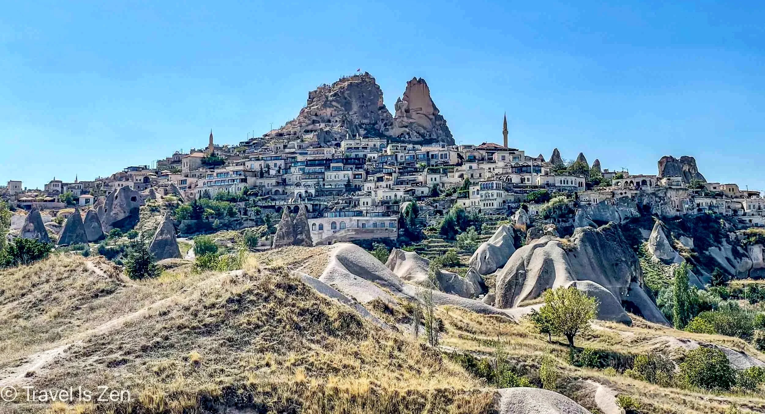
Uçhisar Castle is a massive natural rock outcrop—the tallest point in Cappadocia—riddled with tunnels, rooms, and passageways carved into the soft volcanic tuff. Its name means “outer fortress” (uç hisar in Turkish), a clue to its defensive role.
Uchisar, Cappadocia, Turkey


For millennia, it served various peoples as an advance stronghold, guarding the approach to Nevşehir and the heart of Cappadocia. The first cavities were likely dug by the Hittites over 4,000 years ago, serving as a frontier refuge. After the Hittites, Cappadocia became part of the Persian Empire and was then later influenced by Alexander the Great’s successors in the Hellenistic (Greek) period.


Uçhisar castle and surrounding caves expanded dramatically in the first thousand years of the common era (1st through 11th centuries AD) during the Roman and Byzantine periods. Byzantine era Christians carved chapels into the rock and surrounding caves and linked them with underground tunnels, turning the whole site into a defensive network against Arab raids in the 7th–9th centuries. The underground city of Derinkuyu in Nevsihar is another example. After the fall of the Byzantine Empire, the Seljuks and later the Ottomans continued to use Uçhisar as a stronghold and lookout point. Villages spread around its base and pigeon houses were added to the cliffs for fertilizer and agriculture. Pigeon houses?!

Uçhisar, Cappadocia, Turkey
Pigeon Valley back to Göreme
After our early lunch and quick tour of Uchisar, we continued our day-hike back to Göreme through Pigeon Valley, where the cliffs and soft tuff walls are dotted with thousands of perfectly spaced, small square holes. These nesting chambers for pigeons were carefully hand-carved by people over the centuries, painted with white plaster and decorated with symbols to attract the birds. In Cappadocia’s arid climate, pigeon guano is a natural fertilizer still used today for vineyards, orchards, and gardens.


family fields, Cappadocia, Turkey
The trail through Pigeon Valley wound through family garden plots, showcasing how local farmers grow flowers, fruits, and vegetables out of the dry dusty white volcanic tuff soil. We popped our heads into a few abandoned cave dwellings and passed a few still-inhabited cave homes adapted for modern times with air conditioning units and satellite dishes.
Click any photo for a larger slideshow…


Goreme, Cappadocia, Turkey
We finished our hike back where we started in Göreme earlier that morning. The clockwise loop hike from Göreme, through Rocket Valley, following Zemi Vadisi Yolu into Uchisar, and then returning to Göreme via Pigeon Valley was a total of 9 miles and took us 5 hours (including rest breaks and lunch). The trail is not hard, but it is very dry. Except the wooded area of Zemi Vadisi Yolu, it’s also in full sunshine. We utilized ALL means of sun-protection: hats, 50+ SPF, face/neck buff, and long-sleeves. Our hike map and stats are on Gaia GPS at: https://www.gaiagps.com/public/0Z2BIt4BNl2Yu1of2bQ6c2V1/ Oh, and we ended up hanging out with the same dog the next day when we visited the Dark Church, a UNESCO World Heritage Site. We must have had a connection in a past life. ;-)


