
14K Peak Bagging in Colorado to Acclimate for the John Muir Trail
In April, 2022, we were once again nomadic after a two year pandemic hiatus in Virginia. Craving some altitude, we drove our van cross-country to Breckenridge, Colorado, living for 5 weeks at 10,000+ feet in preparation for our summer through-hike of the John Muir Trail (JMT) in California. As east coast low-landers, we felt we needed some solid experience backpacking at higher elevations before attempting a long distance walk over 11 high mountain passes in the Sierra Nevadas. Acclimating in Colorado, we discovered the joy of 14k “peak bagging”.
Note: For image slide-show, click on any photo.


We rented a condo nestled into the ski slopes of the Tenmile Range, 9,700 feet (around 3,000 meters) above sea level. Our backyard was a trailhead to Peaks 8 and 9 (13,000+ feet). For the first week or so, we huffed and puffed up every incline. Seriously, even the steps to our 2nd floor condo required a moment at the top. After a month (and many UP-ward hikes), we felt a little more comfortable, but let’s be honest — this elevation thing is no joke! I read that it can take more than two years for the body to become fully acclimated to high altitude living. Regardless, we felt tremendous improvement in just a few short weeks.

Hiking to Quandary Peak, Breckenridge, Colorado
We arrived in Breckenridge on June 1, which is a shoulder season for a ski resort. The lifts were closed, but the summer agenda hadn’t yet kicked off. We had the place to ourselves! For the first two weeks, there was still a LOT of snow above 12,000 feet. Since we didn’t have snowshoes, we experienced frequent post-holing and/or had to turn around on some hikes earlier than expected. We were still acclimating, though, so it was probably good that we couldn’t prematurely head too high.
Note: For image slide-show, click on any photo.


Being in Colorado in the late Spring — inhaling the alpine air, feeling the melting snowcaps, watching the Aspens green and the flowers bloom along the great Continental Divide — I was in awe. It’s a massive privilege to have thousands of acres of protected wilderness AND the freedom to roam about where you want, when you want. Maybe it was post-covid and post-desk-job-lock-down appreciation that I felt, but every day in the gorgeous state of Colorado was special and precious: roaring waterfalls, mirror lakes, trees swaying in the wind, the crunch of scree beneath my shoes, slushy postholes, 5:30 am sunrises. Absolute heaven!
Note: For image slide-show, click on any photo.


Just as we were contemplating buying some snowshoes, the summer sun heated up the slopes and we witnessed a swift melt. By the middle of June, we were able to hit the 14,000 feet peaks near Breckenridge and Leadville: Quandary, Lincoln, Democrat, Cameron, Bross, Elbert and Massive. These are some of the tallest peaks in the continental United States.
Quandary Peak (Tenmile Range)
We started with Quandary, the so-called “easy” 14k’r, just a half hour drive from Breckenridge. On our first attempt, we had to turn back at 13,000 feet because of hail, lightening and thunder. We made it to the top on our second attempt a few days later, but it was anything but easy. Despite clear, sunny skies, we battled a strong, unrelenting, freezing wind that nearly knocked us over several times. It was brutal! Fortunately, we were prepared with winter gear (wind-proof jackets, down vests, hats and gloves). Do not EVER under-estimate weather at elevation. The weather in Breckenridge above 12,000 feet is always unpredictable — much colder than anticipated — and can turn nasty within minutes.
Note: For image slide-show, click on any photo.


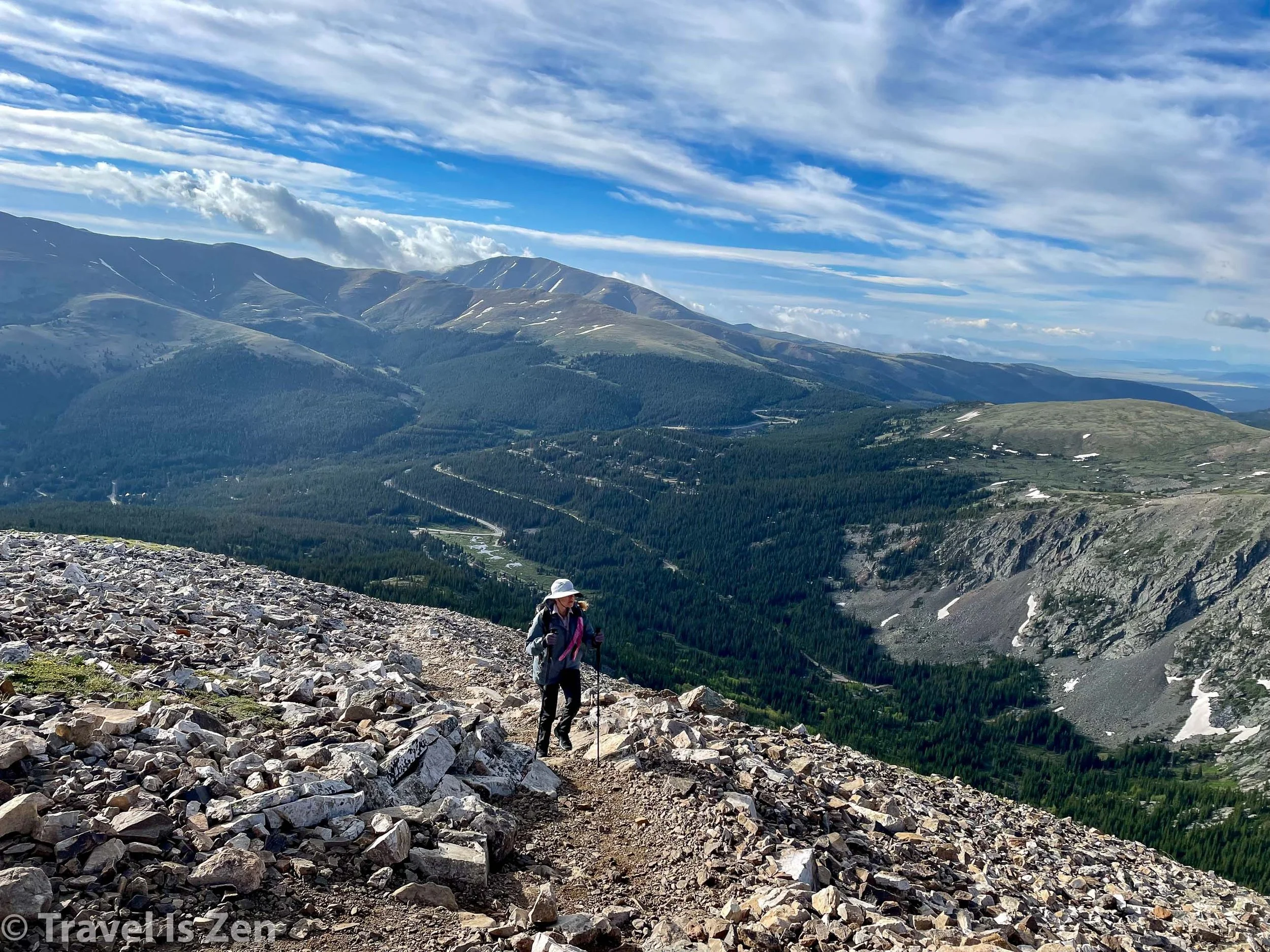


Quandary Peak Summit at 14,271 feet in Breckenridge Colorado
There was still snow at the top of Quandary in mid-June, but it was packed and slushy. We didn’t need snowshoes or spikes. We started at the Quandary Peak trailhead and it took us 6.5 hours to cover the 7+ miles round trip, with ~3,400 feet of elevation gain. Warning: parking at the Quandary Peak trailhead can be expensive - as much as $50 on a holiday weekend! Summit County offers a cheaper shuttle service to / from the trailhead that is accessible from downtown Breckenridge. Another alternative is to park at the Lower McCullough Gulch trailhead; it’s free, but adds another couple of miles to your hike.
“DeCaLiBro” Democrat, Cameron, Lincoln, Bross (Mosquito Range)
We were able to claim the summit of FOUR 14k peaks within a single day on a trail known as DeCaLiBro in the Mosquito Range, again just a short drive from Breckenridge. This is such a cool route! We did the trail backwards (so — we technically did “BroLiCaDe”), starting from the Kite Lake trailhead. Bross was a long and strenuous climb up a rocky scree slope reminiscent of Mt. Kilimanjaro (2 steps forward, 1 step a backslide). At the top, though, was some relief with a relatively flat plateau. From the plateau, we had short climbs to Lincoln and Cameron. Then an unexpectedly tricky and rocky descent of Cameron followed by a Class 2 steep climb to the top of Democrat. Phew!
Note: For image slide-show, click on any photo.


The views throughout the entire hike were vast and awesome! And we got to claim multiple 14k peaks in a single (arduous) day! Similar to Quandary, this hike was 7.6 miles and took us 6.5 hours for the entire loop (including photo ops and snack breaks). Elevation gain was 3,113 feet.
Mt. Elbert and Mt. Massive (Sawatch Range)
Feeling strong and certainly more confident by early July, we then headed to the Sawatch Range to hike the 2nd and 3rd highest peaks in the continental United States (trailing Mt. Whitney in California by just a few hundred feet). Both Mt. Elbert and Mt. Massive are near Leadville Colorado, which is lucky for all pizza-loving hikers because Leadville is also the home of High Mountain Pies YUM YUM YUM!


Leadville offers hikers total perfection: dispersed camping near the trailheads for a pre-sunrise start, exhilarating and challenging summits before the clouds roll in, followed by a relatively short drive back into town where a hungry hiker can stuff one’s face full of fantastic pizza just before the afternoon storm unleashes at full force. When the hail rains down at 2:00 pm, you won’t even care because you’ve already had a can (or 2) of wine (Yes, you read that correctly… I didn’t even know cans of wine were a thing!). I digress.
Mt. Elbert
The main challenge of hiking Mt. Elbert is overcoming the mental disappointment of several false summits. There were at least 3 (maybe 4) times when I reached “the top” only to discover that I had been fooled. Elbert is a tricky son of a gun, with an elusive summit that you never truly see until you’re on it. There are also a few sections that are quite steep and I was thankful to be carrying just a daypack.
Note: For image slide-show, click on any photo.


The reward at the top is an expansive view of the best-of-the-best snow-capped peaks in the Rocky Mountains. We used Peak Visor to familiarize ourselves with the names of some of the more prominent beauties, including the Maroon Bells and Snowmass near Aspen.

There are many routes to reach the peak of Mt. Elbert. We started from the trailhead near Elbert Creek Campground, covering the 9.5 miles to the summit and back in just over 6 hours, with total elevation gain of 4,371 feet. We enjoyed the summit view with about 30 other people coming from every which way!
Mt. Massive
Hiking Mt. Massive was our last 14k summit before heading to California for the John Muir Trail. By this point in early July, we were physically feeling pretty strong. The ongoing challenge was beating down negative thoughts that arise when doing hard things. Once we cleared Mt. Massive’s tree line at about 11,500 feet, we could see the peak and the entire trail leading to it. It seemed so close, but somehow never got any closer! The climb to the saddle is not particularly difficult, but it’s much longer than it looks and I also kept worrying about the “class 2” boulder scramble to the peak. I had some pretty defeating thoughts running through my head that morning. At some point, I had to just put my head down, cut off the thinking, and commit to putting one foot in front of the other; I had to trust that I would eventually get there.
Note: For image slide-show, click on any photo.


Of course, that resolve paid off and we DID reach the summit. The boulder scramble from the saddle to the peak was not a big deal and turned out to be fun! Lesson learned: negative thoughts, worries and fears are not helpful, especially if you’ve already committed to the task. Just cut them off and “do the thing”.

Post-JMT Thoughts on Acclimating in Colorado
Spending more than a month in Colorado, living and playing above 10,000 feet, prepared us well for the John Muir Trail experience. If anything, it was a little overkill — but still a ton of fun! The Rocky Mountains are quite different from the Sierra Nevada Mountains, but they were the perfect training ground for us to acclimate, gear-test, and build some trail muscles before heading into the California wilderness. In addition to bagging 14k peaks in Breckenridge, we also did some multi-night camping and hiking in Aspen and in the San Juan mountains in southern Colorado, helping us gain experience and equipment confidence before heading to California.
Now that we’ve completed the 200+ mile JMT, we’ve got our sights set on a future Colorado Trail through-hike, which will be double the distance of the JMT. Maybe we should train for that in the California Sierras?? Ha!


