
John Muir Trail: Days 1-5 Lyell Canyon to Reds Meadow
Our official starting point for the John Muir Trail (JMT) was Tuolumne Meadows, heading southbound (SOBO) to Lyell Canyon. With clean clothes and a fresh shampoo smell, Caffrey, our friend Dan Chung and I hopped off the YART shuttle from Mammoth Lakes at the Tuolumne Meadows post office on Friday, July 22, 2022. Big smiles as we began our hike at 9:00 a.m. at an elevation of 8,000 feet.
This post covers the first leg of our JMT hike, from Tuolumne Meadows to our re-supply at Reds Meadow (roughly miles 23-60 of the JMT heading SOBO). Highlights in this section include: Lyell Canyon, Donahue Pass, Maries Lakes, Thousand Islands and Garnet Lakes, Mts. Lyell, Banner and Ritter, Shadow Lake, Devils Postpile, and Reds Meadow.


Camp #1: Lyell Forks (8.5 miles) @ 9,000 feet
Our packs were full for the first time and Caffrey was nursing a grade 2 sprained ankle from a mis-step at Angels Landing in Utah the week prior. We set a moderate goal of 6 miles for our first day. The sun was shining and the temperature was pleasant, not a cloud in the sky as we walked along the dry, sandy trail. Crossing the wooden footbridge at Dana Forks in Tuolumne Meadows, we briefly chatted with a park ranger offering commentary on the meadowlands. Near noon, Caffrey’s ankle was feeling a little cranky. When we spied a bubbly natural “spa”, we couldn’t resist a soothing foot bath and head dunk. Revived and refreshed, we had our first trail meal - tuna wraps with Cheetos - and continued on our way.
Note: For image slide-show, click on any photo.


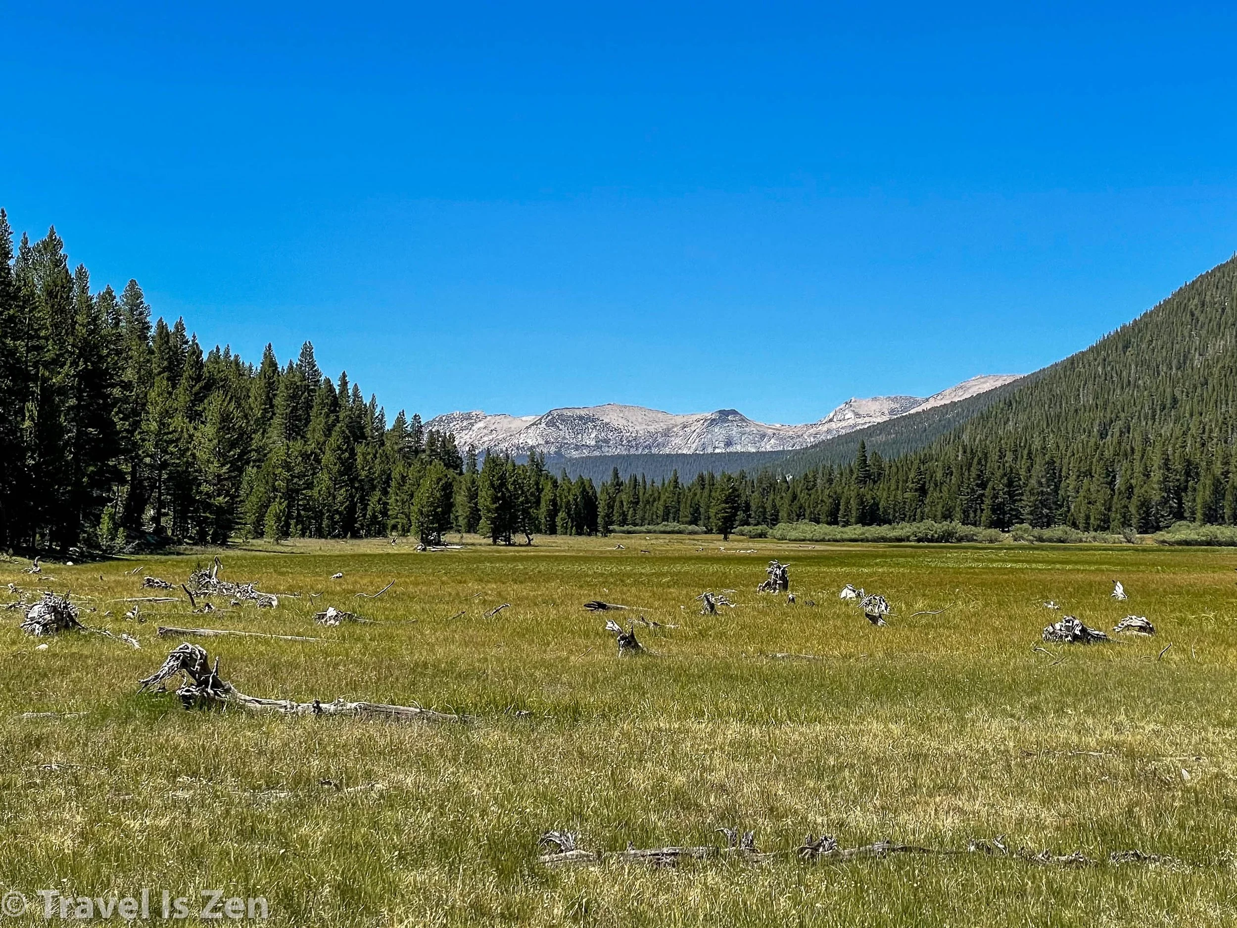
I was expecting Lyell Canyon to be more of a narrow, dark gorge. Instead, it’s a wide glacier-carved, u-shaped valley through which Lyell Fork flows, eventually merging with the Tuolumne River on its way to Yosemite Valley. We walked through subalpine forests of white pine, hemlock, and lodgepole and across broad scrub-grass fields littered with tree corpses. The going was easy and Caffrey’s swollen ankle was holding up well after the mineral spring, so when we reached the Evelyn Lakes trail junction, we pressed onward another 2.5 miles before setting up our first camp at around 9,000 feet.

A little commentary about camping on the JMT. We learned that you sometimes need to hunt around a bit to find “marked” camp sites. They are typically a few hundred feet off the trail, within easy walking distance of water, leveled and cleared of brush — and, um, read nearby signs! On our first camp selection, we set up our tent under some pine trees and disappointedly griped about “all the donkey poo” around. It took us another 30 minutes to discover that we had settled in a "stock camp”. Ewww! Caffrey hunted around a bit on the opposite side of the trail and we found an excellent camp site with a couch-shaped log on which to relax, loads of privacy, and no poo.

Journaling and chillin’ after our first day on the trail
It was 3:30 p.m. when we re-camped, giving us time to wash off in the creek, enjoy the afternoon sunshine, and listen to nothing but the wind. The sun dipped behind the mountain around 6:00 p.m. as we cooked dinner. With the mosquitos starting to bite, we were in the tent and closing our eyes at 7:30 p.m. I intended to listen to a podcast, but fell asleep before acting on that intention. Total ascent on our first JMT trail day: ~1,400 feet.
Camp #2: Marie Lakes (9 miles) @ 10,800 feet
At 5:00 a.m., the air was quite cold - probably high 40’s! We ate breakfast in our puffy coats and gloves, but we were able to shed the layers just before heading out around 6:45. Today’s mission was to tackle our first Sierra high mountain pass: Donahue! At the end of Lyell Canyon, the trail ascended fast, wiggling between Mount Donahue and Mount Lyell. We passed two beautiful alpine lakes near the base of Mount Lyell before crossing the broad and rocky pass at 11,000 feet. Caffrey’s ankle and Dan’s barely-acclimated lungs handled the first challenge well! Donahue Pass would have been a bit anti-climactic except for the smoke drifting in from Yosemite. Skies that were clear only moments earlier became yellow and hazy; we could smell the fire. Hikers we met a few days later told us that their permits from Yosemite Valley and Tuolumne Meadows were cancelled due to the smoke on the weekend of July 23-24; they were forced to find alternate trailheads.
Note: For image slide-show, click on any photo.


Hazy skies, yellow smoke over Mt. Lyell, JMT, California
Coming down the other side, the air was more clear. After a tuna wrap lunch and another mid-afternoon cooling foot bath, we decided to explore off the JMT. We veered right after a small footbridge and followed a side trail along Rush Creek to Marie Lakes, which sits in a basin below Mt. Lyell (the tallest peak in Yosemite). On the map, the 1,000 foot climb to Marie Lakes didn’t look too intimidating. In reality, it was rocky, rugged, steep and not well-maintained. From all of our acclimatization hikes in Colorado, Caffrey and I were familiar with the landscape and glacier lakes above the tree line - but this was all new to Dan, coming in fresh from the east coast. He grumbled and grunted the entire way up the very steep trail. Caffrey and I could feel daggers of blame emanating from our buddy, who kept insisting that there was “no way” a lake was going to be this high up. Ha ha! Once we arrived, witnessed the lakes and set up camp, Dan relaxed and admitted it was pretty cool. We had the whole area to ourselves! The silence and night sky were incredible.
Note: For image slide-show, click on any photo.


Camp #3: Cliffs Above Shadow Creek (12.2 miles) @ 9,200 feet
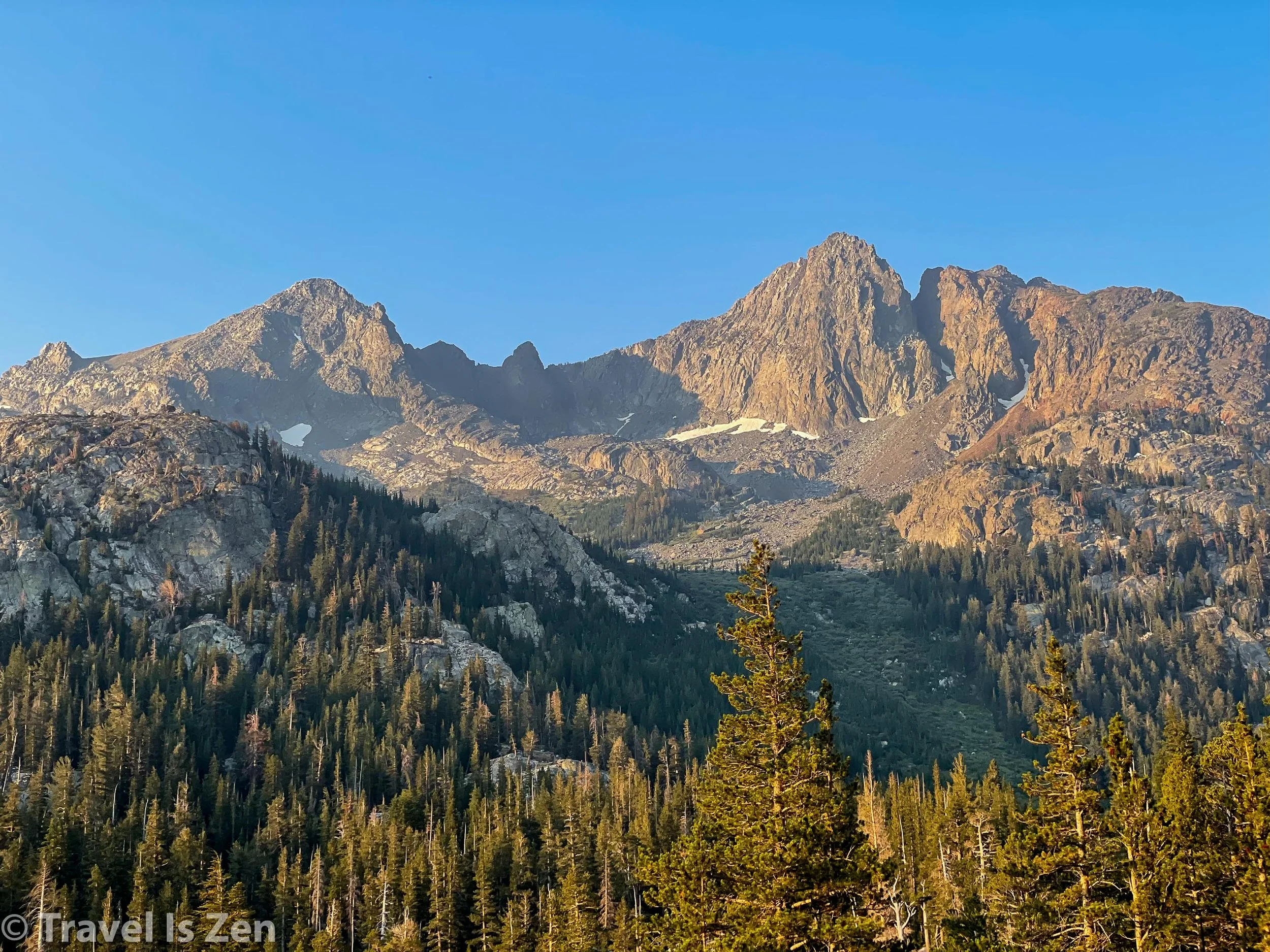
The 12 miles we walked on the 3rd day were some of the most gorgeous, scenic miles of the entire trail. We hiked down from Marie Lakes at 7:00 a.m. and re-joined the John Muir Trail, with Mount Ritter and Mount Banner sitting prettily in the distance. The path was lined with colorful wildflowers as we went up and over Island Pass (10,220 feet) and into the land o’lakes: Thousand Islands, Garnet, Emerald, and Ruby.
Note: For image slide-show, click on any photo.


We were lucky to still be here on the trail. Earlier in the morning, we had quite a scare when Caffrey tripped on a rock, landed on his already-sprained ankle, and fell to the ground in agonizing pain. It happened near a stream, so he was able to soak his foot in the cold water for 30 minutes, wrap an ace bandage around the joint, take some ibuprofen, and eventually put some weight on it as the swelling went down. We were fortunately able to keep moving forward, but it was touch-and-go for a while there, reminding us to appreciate every moment we DO have on the trail because it could end with a single mis-step.
We stopped often for photos and rest, basking in the scenery. We hit the steep switchback after Garnet Lake in the hottest part of the day. I neglected to check my water before heading up the hill and ended up hiking 2.5 miles with a parched throat after discovering a mapped water source was dry. This was one of the rare points on the trail without predictable water - totally my mistake for not filling up at Garnet Lake. We arrived at Shadow Creek as the sun was getting low in the sky.

Waterfall at Shadow Creek, John Muir Trail, California
As we were about to pitch our tents, a ranger emerged out of nowhere and informed us that camping at Shadow Creek was prohibited due to forest restoration. He gave us directions to a few sites hidden in the cliffs about a mile back up the trail. I was a little grumpy to back-track, but the mood didn’t last long. Our camp was perched on a cliff, with a front row sunset show. Day’s total ascent was 1,538 feet and descent was 2,585 feet. Slope averaged 418 feet/mile.


Camp #4: Reds Meadow Campground (~10 miles) @ 7,500 feet + a ZERO day
Passing Shadow Creek in the early dawn on our 4th day of hiking, we soon had an eye-opening climb up a gazillion switchbacks.

Dawn at Shadow Creek, John Muir Trail, Sierra Nevadas


Thank goodness for switchbacks, though, ‘cause that was one steep hill! From the top, it was a long…long…long descent over 2,500 feet to Reds Meadow Resort through a parched, dusty landscape. We passed a sweaty California Conservation Corps crew doing trail work and thanked them for their volunteer service — then humbly ambled onward. No feeling sorry for our dirty selves when these folks were out there humping it for our benefit!
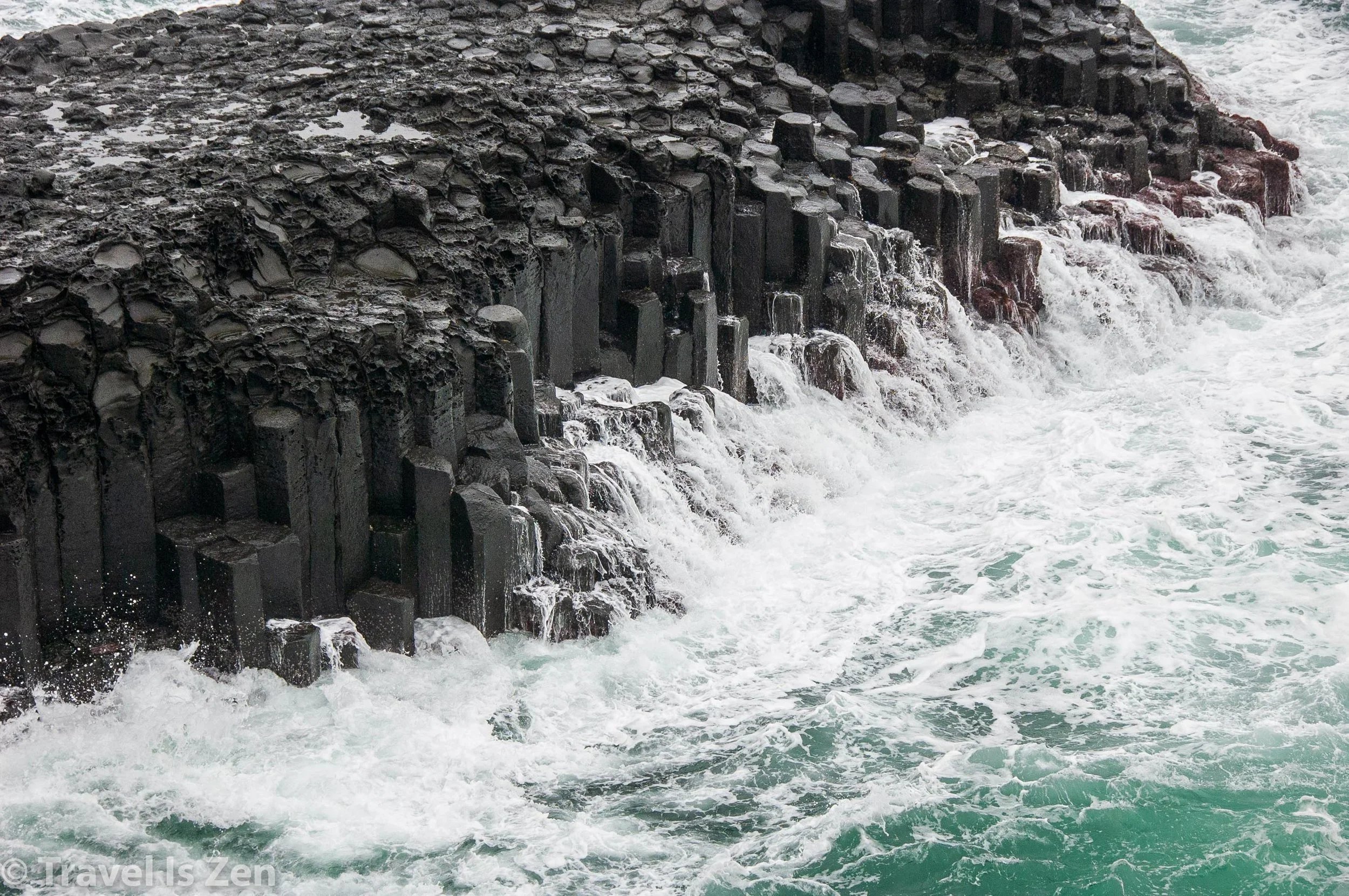
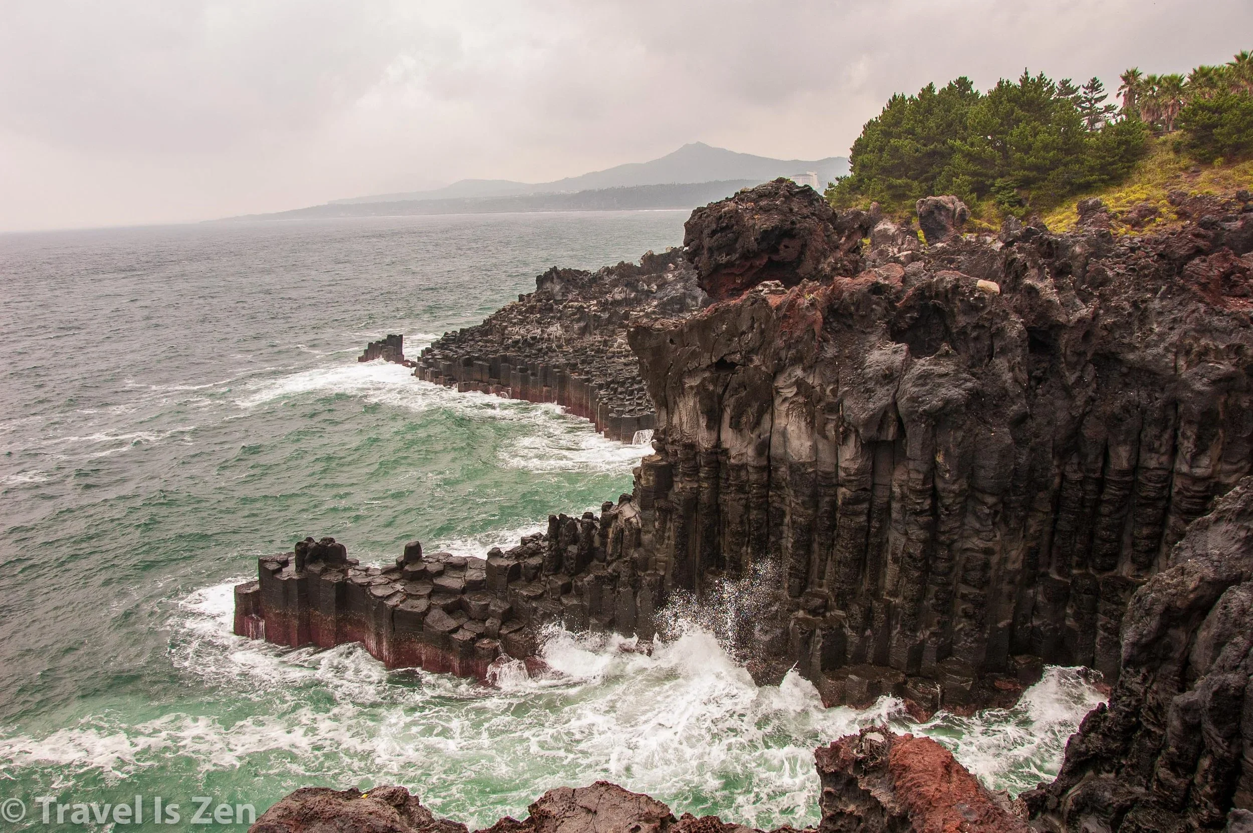
We once again diverted off the John Muir Trail onto a side trail to Devils Postpile National Monument. This is actually the 2nd time that we have seen this type of volcanic columnar basalt. Another fine example is in South Korea’s Jeju Island. These hexagonal columns occur naturally when lava cools and contracts. Cool!


Reds Meadow Resort was just a short walk from Devils Postpile. The camp hostess, Cindy, was extremely helpful and knowledgeable and kept the toilets sparkling clean. Did I say toilets?? Yes!! We re-entered civilization after 4 days in the wilderness. After setting up our tents, we picked up our re-supply buckets and joined fellow hikers for some beers and (veggie) burgers. SWEET!!


We took a ZERO day on day #5 to rest, enjoy the 105 degree hot spring (oh so needed!!!), eat pancakes and burritos, and make new friends (the musician Karina, the NOBO four-some: Mary-Jo, Vince, Al and Leese, and Mr. Japanese Sensai). We also did a reality check on our re-supply and ended up ditching a lot of food items. When we were menu-planning, I carefully calculated calories per day vs. expected energy burn along with macro-nutrient balance. Turns out that we just couldn’t eat as much as we planned. Yeah, we were probably operating on a net-loss calorie intake, but it wasn’t a big deal for just a three week hike. We collectively tossed about this much at every re-supply point. Doh! No wonder hiker boxes are always overflowing!

The food we tossed after re-supply at Reds Meadow
We really needed that zero day. I was developing a painful right knee due to a super-tight calf and IT band. Caffrey’s ankle was also pretty swollen. We spent the day relaxing, hydrating, eating, bathing, sleeping, and re-charging for stage 2, which would take us deeper into the Sierras to Vermilion Valley Resort (VVR).


